
Köpenick topographic map
Interactive map
Click on the map to display elevation.
About this map
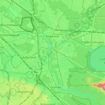
Name: Köpenick topographic map, elevation, terrain.
Location: Köpenick, Treptow-Köpenick, Berlin, Germany (52.40166 13.54812 52.48112 13.67806)
Average elevation: 128 ft
Minimum elevation: 33 ft
Maximum elevation: 338 ft
Other topographic maps
Click on a map to view its topography, its elevation and its terrain.
Friedrichshain-Kreuzberg
Friedrichshain-Kreuzberg, Berlin, Germany
Average elevation: 148 ft
Charlottenburg-Wilmersdorf
Charlottenburg-Wilmersdorf, Berlin, Germany
Average elevation: 144 ft
Schöneberg
Schöneberg, Tempelhof-Schöneberg, Berlin, Germany
Average elevation: 151 ft