
Lake Sammamish topographic map
Interactive map
Click on the map to display elevation.
About this map
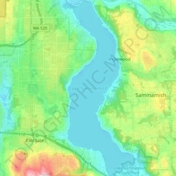
Name: Lake Sammamish topographic map, elevation, terrain.
Average elevation: 289 ft
Minimum elevation: 0 ft
Maximum elevation: 1,129 ft
King County trails, hiking, mountain biking, running and outdoor activities
Other topographic maps
Click on a map to view its topography, its elevation and its terrain.
West Tiger Mountain Natural Resource Conservation Area
United States > Washington > King County > Issaquah
Average elevation: 331 ft