Geolocate

Ashley National Forest topographic map

Interactive map

Click on the map to display elevation.

About this map

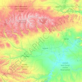
Name: Ashley National Forest topographic map, elevation, terrain.

Location: Ashley National Forest, Utah, United States of America (39.86976 -111.03895 40.96517 -109.24133)

Average elevation: 7,375 ft

Minimum elevation: 4,610 ft

Maximum elevation: 13,412 ft

Other topographic maps

Click on a map to view its topography, its elevation and its terrain.

Jackson Hole

United States of America > Utah

Jackson Hole, Grand County, Utah, United States of America

Average elevation: 4,308 ft

Wasatch Range

United States of America > Utah > Sandy

Wasatch Range, Sandy, Salt Lake County, Utah, United States of America

Average elevation: 6,168 ft

Hyrum

United States of America > Utah > Hyrum

Hyrum, Cache County, Utah, United States of America

Average elevation: 4,731 ft

Mount Nebo

United States of America > Utah

Mount Nebo, Juab County, Utah, United States of America

Average elevation: 10,220 ft

Moon Apartments

United States of America > Utah > Provo > Moon Apartments

Moon Apartments, Provo, Utah County, Utah, 84601, United States of America

Average elevation: 4,662 ft

Towne Center Apartments

United States of America > Utah > Herriman > Towne Center Apartments

Towne Center Apartments, Herriman, Salt Lake County, Utah, 84096, United States of America

Average elevation: 4,813 ft

(West) Mueller Park

United States of America > Utah > Bountiful

(West) Mueller Park, Bountiful, Davis County, Utah, United States of America

Average elevation: 4,833 ft

Linden Circle

United States of America > Utah > Holladay

Linden Circle, Holladay, Salt Lake County, Utah, 85412, United States of America

Average elevation: 4,478 ft

Eddie Kay

United States of America > Utah > Millcreek

Eddie Kay, Millcreek, Salt Lake County, Utah, 84117, United States of America

Average elevation: 4,367 ft

Wendover

United States of America > Utah > Wendover

Wendover, Tooele County, Utah, 84083, United States of America

Average elevation: 4,491 ft

Salt Point

United States of America > Utah

Salt Point, Emery County, Utah, United States of America

Average elevation: 5,942 ft

Twin Peaks

United States of America > Utah > Midvale

Twin Peaks, Midvale, Salt Lake County, Utah, 84107, United States of America

Average elevation: 4,386 ft