
Make a donation
Gear up for your next adventure:
As an Amazon Associate, this site earns from qualifying purchases at no extra cost to you.
Assebroek topographic map
Click on the map to display elevation.
Make a donation
Gear up for your next adventure:
As an Amazon Associate, this site earns from qualifying purchases at no extra cost to you.
Assebroek
Het vierde leen, bekend onder de namen "Ter Lake", "Boechout" of "Buggenhout", lag net buiten de Brugse stadsomwalling, ter hoogte van de huidige Vrijheidsstraat. Van dit domein, dat ontstaan was op gronden van de heren van Gruuthuse, blijft heden niets over. Naast deze vier leenhoven waren er nog enkele gewone lenen zonder rechtsmacht.
Make a donation
Gear up for your next adventure:
As an Amazon Associate, this site earns from qualifying purchases at no extra cost to you.
About this map
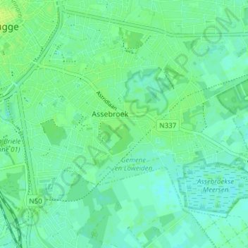
Name: Assebroek topographic map, elevation, terrain.
Location: Assebroek, Brugge, West-Vlaanderen, Vlaanderen, 8310, België (51.17853 3.22775 51.20787 3.28973)
Average elevation: 16 ft
Minimum elevation: 3 ft
Maximum elevation: 39 ft
Make a donation
Gear up for your next adventure:
As an Amazon Associate, this site earns from qualifying purchases at no extra cost to you.
Other topographic maps
Click on a map to view its topography, its elevation and its terrain.
Make a donation
Gear up for your next adventure:
As an Amazon Associate, this site earns from qualifying purchases at no extra cost to you.