
Make a donation
Gear up for your next adventure:
As an Amazon Associate, this site earns from qualifying purchases at no extra cost to you.
Memphis topographic map
Click on the map to display elevation.
Make a donation
Gear up for your next adventure:
As an Amazon Associate, this site earns from qualifying purchases at no extra cost to you.
Memphis
Memphis is characterized by a varied topography shaped by its location on the Chickasaw Bluffs overlooking the Mississippi River. The city itself sits at an elevation of about 300 feet, providing a scenic view of the river valley below. To the west, the landscape transitions into the Mississippi Alluvial Plain, which features low-lying floodplains and rolling hills, a stark contrast to the steeper bluffs that define the eastern edges of the city. This topographical arrangement creates a unique blend of elevations and landforms, including levees and terraces formed by centuries of river sedimentation, contributing to both the ecological diversity and the urban development of Memphis. The proximity to the Mississippi River also plays a crucial role in the local climate and ecosystems, fostering rich habitats and agricultural opportunities.
Make a donation
Gear up for your next adventure:
As an Amazon Associate, this site earns from qualifying purchases at no extra cost to you.
About this map
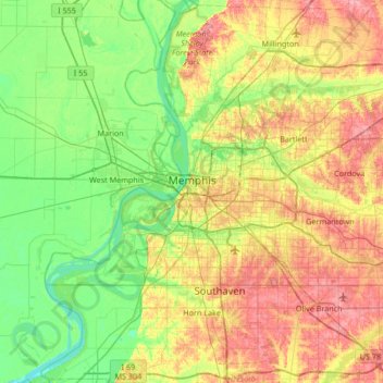
Name: Memphis topographic map, elevation, terrain.
Average elevation: 282 ft
Minimum elevation: 164 ft
Maximum elevation: 446 ft
Shelby County trails, hiking, mountain biking, running and outdoor activities
Make a donation
Gear up for your next adventure:
As an Amazon Associate, this site earns from qualifying purchases at no extra cost to you.
Other topographic maps
Click on a map to view its topography, its elevation and its terrain.
North Forrest bend beach
United States > Tennessee > Shelby County > Collierville
Average elevation: 299 ft
Make a donation
Gear up for your next adventure:
As an Amazon Associate, this site earns from qualifying purchases at no extra cost to you.
Make a donation
Gear up for your next adventure:
As an Amazon Associate, this site earns from qualifying purchases at no extra cost to you.
Cordova
United States > Tennessee > Shelby County > Memphis
Cordova is a community in Shelby County, Tennessee, United States. Cordova lies east of Memphis, north of Germantown, south of Bartlett, and northwest of Collierville at an elevation of 361 feet (110 meters).
Average elevation: 325 ft
Make a donation
Gear up for your next adventure:
As an Amazon Associate, this site earns from qualifying purchases at no extra cost to you.
Make a donation
Gear up for your next adventure:
As an Amazon Associate, this site earns from qualifying purchases at no extra cost to you.