Geolocate

Amicalola Falls topographic map

Interactive map

Click on the map to display elevation.

About this map

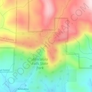
Name: Amicalola Falls topographic map, elevation, terrain.

Location: Amicalola Falls, Dawson County, Georgia, United States (34.56736 -84.24432 34.56746 -84.24422)

Average elevation: 2,310 ft

Minimum elevation: 1,713 ft

Maximum elevation: 2,963 ft

Other topographic maps

Click on a map to view its topography, its elevation and its terrain.

Amicalola Falls

United States > Georgia > Dawson County

Amicalola Falls, Dawson County, Georgia, United States

Average elevation: 2,293 ft

Barrettsville

United States > Georgia > Dawson County

Barrettsville, Dawson County, Georgia, United States

Average elevation: 1,175 ft

Dawsonville

United States > Georgia > Dawson County

Dawsonville, Dawson County, Georgia, United States

Average elevation: 1,352 ft

Amicalola Falls State Park

United States > Georgia > Dawson County

Amicalola Falls State Park, Dawson County, Georgia, United States

Average elevation: 2,336 ft