
Make a donation
Gear up for your next adventure:
As an Amazon Associate, this site earns from qualifying purchases at no extra cost to you.
Chattanooga topographic map
Click on the map to display elevation.
Make a donation
Gear up for your next adventure:
As an Amazon Associate, this site earns from qualifying purchases at no extra cost to you.
Chattanooga
Chattanooga showcases a diverse and striking topography that is defined by its position within the Appalachian region. Nestled between the rugged Ridge-and-Valley Appalachians and the Cumberland Plateau, the city is framed by dramatic hills and valleys, creating a visually compelling landscape. The Tennessee River flows through the heart of Chattanooga, acting as a natural dividing line and enhancing the area's scenic beauty. With downtown elevations around 676 feet (206 meters), the city rises to nearby ridges, reaching peaks of about 2,400 feet (730 meters) on Lookout Mountain and other surrounding highlands. This varied elevation contributes to numerous recreational opportunities, including hiking, mountain biking, and rock climbing, making Chattanooga a vibrant outdoor destination.
Make a donation
Gear up for your next adventure:
As an Amazon Associate, this site earns from qualifying purchases at no extra cost to you.
About this map
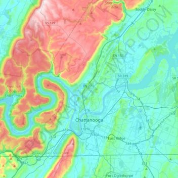
Name: Chattanooga topographic map, elevation, terrain.
Average elevation: 1,086 ft
Minimum elevation: 620 ft
Maximum elevation: 2,369 ft
Hamilton County trails, hiking, mountain biking, running and outdoor activities
Make a donation
Gear up for your next adventure:
As an Amazon Associate, this site earns from qualifying purchases at no extra cost to you.
Other topographic maps
Click on a map to view its topography, its elevation and its terrain.
Signal Terrace
United States > Tennessee > Hamilton County > Signal Mountain
Average elevation: 1,686 ft
Shepherd Forest
United States > Tennessee > Hamilton County > Signal Mountain
Average elevation: 1,506 ft
Make a donation
Gear up for your next adventure:
As an Amazon Associate, this site earns from qualifying purchases at no extra cost to you.
Make a donation
Gear up for your next adventure:
As an Amazon Associate, this site earns from qualifying purchases at no extra cost to you.
Make a donation
Gear up for your next adventure:
As an Amazon Associate, this site earns from qualifying purchases at no extra cost to you.
Make a donation
Gear up for your next adventure:
As an Amazon Associate, this site earns from qualifying purchases at no extra cost to you.
Brainerd
United States > Tennessee > Hamilton County > Chattanooga > Ridgeside
Average elevation: 768 ft
Make a donation
Gear up for your next adventure:
As an Amazon Associate, this site earns from qualifying purchases at no extra cost to you.
Mountain Ridge
United States > Tennessee > Hamilton County > Chattanooga > Red Bank
Average elevation: 817 ft
Make a donation
Gear up for your next adventure:
As an Amazon Associate, this site earns from qualifying purchases at no extra cost to you.
Wilder Point
United States > Tennessee > Hamilton County > Signal Mountain > Palisades
Average elevation: 1,342 ft
Make a donation
Gear up for your next adventure:
As an Amazon Associate, this site earns from qualifying purchases at no extra cost to you.
Carriage Hill
United States > Tennessee > Hamilton County > Signal Mountain
Average elevation: 1,283 ft
South Brainerd
United States > Tennessee > Hamilton County > Chattanooga > East Ridge
Average elevation: 732 ft
Make a donation
Gear up for your next adventure:
As an Amazon Associate, this site earns from qualifying purchases at no extra cost to you.
Make a donation
Gear up for your next adventure:
As an Amazon Associate, this site earns from qualifying purchases at no extra cost to you.
Northshore Estates
United States > Tennessee > Hamilton County > Chattanooga > Northshore Estates
Average elevation: 732 ft
Brookfield
United States > Tennessee > Hamilton County > East Ridge > Brookfield
Average elevation: 771 ft
Make a donation
Gear up for your next adventure:
As an Amazon Associate, this site earns from qualifying purchases at no extra cost to you.
Soddy-Daisy
United States > Tennessee > Hamilton County > Soddy-Daisy > Soddy-Daisy
Average elevation: 1,007 ft
Make a donation
Gear up for your next adventure:
As an Amazon Associate, this site earns from qualifying purchases at no extra cost to you.
Regency Place
United States > Tennessee > Hamilton County > Chattanooga > Ridgeside
Average elevation: 768 ft