
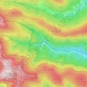
Hinterlangenbach topographic map
Interactive map
Click on the map to display elevation.
About this map
Name: Hinterlangenbach topographic map, elevation, terrain.
Average elevation: 2,785 ft
Minimum elevation: 2,018 ft
Maximum elevation: 3,563 ft
Other topographic maps
Click on a map to view its topography, its elevation and its terrain.
Röt
Deutschland > Baden-Württemberg > Landkreis Freudenstadt > Baiersbronn
Das Gemeindegebiet von Baiersbronn erstreckt sich vom Murgtal in 450 m ü. NHN bis zum Dreifürstenstein östlich der Hornisgrinde in 1153 m Höhe, der zugleich den höchsten Punkt in Württemberg darstellt. Beim Dreifürstenstein befand sich auch der westlichste Punkt des Landes Württemberg in den auf dem…
Average elevation: 2,260 ft
Bergergrund
Deutschland > Baden-Württemberg > Landkreis Freudenstadt > Baiersbronn
Average elevation: 2,188 ft
Wilder See
Deutschland > Baden-Württemberg > Landkreis Freudenstadt > Baiersbronn
Gelegentlich verwechselt wird der Wildsee mit dem 20 km nordöstlich und nahezu in gleicher Höhe gelegenen, aber ganz andersartigen Hochmoorkolk Wildsee bei Kaltenbronn.
Average elevation: 3,061 ft
Ellbachsee
Deutschland > Baden-Württemberg > Landkreis Freudenstadt > Baiersbronn
Average elevation: 2,792 ft