
Mount Desert Island topographic map
Interactive map
Click on the map to display elevation.
About this map
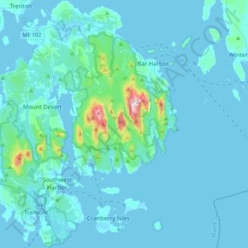
Name: Mount Desert Island topographic map, elevation, terrain.
Location: Mount Desert Island, Hancock County, Maine, United States (44.22169 -68.43149 44.44446 -68.17348)
Average elevation: 95 ft
Minimum elevation: -13 ft
Maximum elevation: 1,503 ft
Hancock County trails, hiking, mountain biking, running and outdoor activities
Other topographic maps
Click on a map to view its topography, its elevation and its terrain.