
Lake Havasu topographic map
Interactive map
Click on the map to display elevation.
About this map
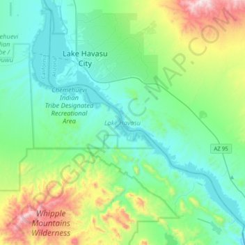
Name: Lake Havasu topographic map, elevation, terrain.
Location: Lake Havasu, Mohave County, Arizona, United States (34.28853 -114.40524 34.53240 -114.09679)
Average elevation: 1,276 ft
Minimum elevation: 377 ft
Maximum elevation: 4,344 ft
Mohave County trails, hiking, mountain biking, running and outdoor activities