
Oudenaarde topographic map
Interactive map
Click on the map to display elevation.
About this map
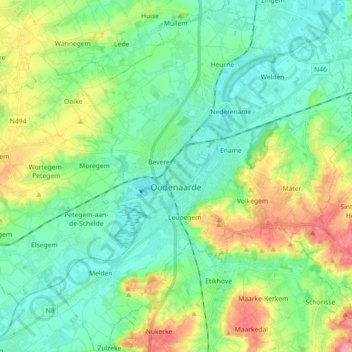
Name: Oudenaarde topographic map, elevation, terrain.
Location: Oudenaarde, East Flanders, Flanders, 9700, Belgium (50.79001 3.54088 50.90389 3.69769)
Average elevation: 115 ft
Minimum elevation: 7 ft
Maximum elevation: 381 ft
Other topographic maps
Click on a map to view its topography, its elevation and its terrain.