
Clinton Township topographic map
Interactive map
Click on the map to display elevation.
About this map
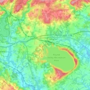
Name: Clinton Township topographic map, elevation, terrain.
Average elevation: 374 ft
Minimum elevation: 128 ft
Maximum elevation: 938 ft
Hunterdon County trails, hiking, mountain biking, running and outdoor activities
Other topographic maps
Click on a map to view its topography, its elevation and its terrain.
Ringoes
United States > New Jersey > Hunterdon County > East Amwell Township
Average elevation: 246 ft
Quakertown
United States > New Jersey > Hunterdon County > Franklin Township
Average elevation: 571 ft
Rileyville
United States > New Jersey > Hunterdon County > East Amwell Township
Average elevation: 410 ft
Raven Rock
United States > New Jersey > Hunterdon County > Delaware Township
Average elevation: 285 ft
Pleasant Run
United States > New Jersey > Hunterdon County > Readington Township
Average elevation: 207 ft
Whitehouse Station
United States > New Jersey > Hunterdon County > Readington Township
Average elevation: 200 ft
Ringoes
United States > New Jersey > Hunterdon County > East Amwell Township
Average elevation: 246 ft
Larisons Corners
United States > New Jersey > Hunterdon County > Larisons Corners
Average elevation: 217 ft