
Greenville topographic map
Interactive map
Click on the map to display elevation.
About this map
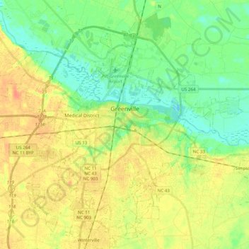
Name: Greenville topographic map, elevation, terrain.
Location: Greenville, Pitt County, North Carolina, United States (35.52978 -77.47527 35.67605 -77.27931)
Average elevation: 52 ft
Minimum elevation: -10 ft
Maximum elevation: 108 ft
Pitt County trails, hiking, mountain biking, running and outdoor activities
Other topographic maps
Click on a map to view its topography, its elevation and its terrain.
Hartington and Williams
United States > North Carolina > Pitt County > Greenville
Average elevation: 43 ft
Robinson Heights
United States > North Carolina > Pitt County > Winterville > Robinson Heights
Average elevation: 75 ft
Hartington and Williams
United States > North Carolina > Pitt County > Greenville > Hartington and Williams
Average elevation: 43 ft