
Kent County topographic map
Interactive map
Click on the map to display elevation.
About this map
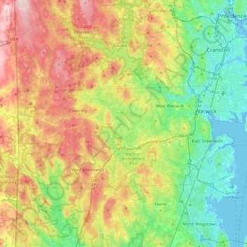
Name: Kent County topographic map, elevation, terrain.
Location: Kent County, Rhode Island, United States (41.59676 -71.78970 41.76833 -71.35666)
Average elevation: 302 ft
Minimum elevation: -23 ft
Maximum elevation: 791 ft
Rhode Island trails, hiking, mountain biking, running and outdoor activities
Other topographic maps
Click on a map to view its topography, its elevation and its terrain.
Diamond Hill Park
United States > Rhode Island > Providence County > Cumberland > Diamond Hill
Average elevation: 272 ft
Slatersville
United States > Rhode Island > Providence County > North Smithfield
Average elevation: 285 ft
Wakefield
United States > Rhode Island > South County > South Kingstown > Wakefield
Average elevation: 75 ft
Olneyville
United States > Rhode Island > Providence County > Providence > Olneyville
Average elevation: 79 ft
Conservation Land (Trails)
United States > Rhode Island > Providence County > Cumberland
Average elevation: 240 ft
Saunderstown
United States > Rhode Island > South County > North Kingstown > Saunderstown
Average elevation: 46 ft