
Sereď topographic map
Interactive map
Click on the map to display elevation.
About this map
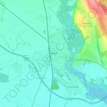
Name: Sereď topographic map, elevation, terrain.
Average elevation: 433 ft
Minimum elevation: 384 ft
Maximum elevation: 669 ft
Sereď lies at an altitude of 129 metres (423 ft) above sea level and covers an area of 30.454 square kilometres (11.8 sq mi). It is located in the Danubian Lowland on the Váh river, around 20 kilometres (12 mi) south-east of Trnava, 33 kilometres (21 mi) west of Nitra and around 55 kilometres (34 mi) east from Bratislava. The closest mountain ranges are the Little Carpathians to the west and Považský Inovec to the north.
Other topographic maps
Click on a map to view its topography, its elevation and its terrain.
Sládkovičovo
Slovakia > Region of Trnava > District of Galanta
Sládkovičovo, District of Galanta, Region of Trnava, Western Slovakia, 925 21, Slovakia
Average elevation: 394 ft
Šintava
Slovakia > Region of Trnava > District of Galanta
Šintava, District of Galanta, Region of Trnava, Western Slovakia, 925 51, Slovakia
Average elevation: 453 ft