
Lincoln topographic map
Interactive map
Click on the map to display elevation.
Lincoln
Lincoln is drained by the Pemigewasset River and its East Branch. Lincoln lies almost fully within the Merrimack River watershed, with the western edge of town in the Connecticut River watershed. Kancamagus Pass, elevation 2,860 feet (870 m), is on the Kancamagus Highway at the eastern boundary. The highest point in Lincoln is the summit of Mount Bond at 4,698 ft (1,432 m) above sea level.
About this map
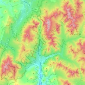
Name: Lincoln topographic map, elevation, terrain.
Location: Lincoln, Grafton County, New Hampshire, 03251, United States (44.00095 -71.77239 44.19788 -71.39812)
Average elevation: 2,221 ft
Minimum elevation: 614 ft
Maximum elevation: 5,190 ft
Grafton County trails, hiking, mountain biking, running and outdoor activities
Other topographic maps
Click on a map to view its topography, its elevation and its terrain.
Stinson Lake
United States > New Hampshire > Grafton County > Rumney > Stinson Lake
Average elevation: 1,509 ft
Mount Kineo, East Peak
United States > New Hampshire > Grafton County > Ellsworth
Average elevation: 2,329 ft
West Lebanon
United States > New Hampshire > Grafton County > Lebanon > West Lebanon
Average elevation: 541 ft
North Littleton
United States > New Hampshire > Grafton County > Littleton > North Littleton
Average elevation: 1,093 ft
LeBruns Mobile Home Park
United States > New Hampshire > Grafton County > Lebanon > LeBruns Mobile Home Park
Average elevation: 1,070 ft