
Middletown topographic map
Interactive map
Click on the map to display elevation.
About this map
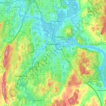
Name: Middletown topographic map, elevation, terrain.
Average elevation: 249 ft
Minimum elevation: -7 ft
Maximum elevation: 860 ft
Other topographic maps
Click on a map to view its topography, its elevation and its terrain.
Hurd State Park
United States > Connecticut > Lower Connecticut River Valley Planning Region > East Hampton
Average elevation: 249 ft
Mount Higby
United States > Connecticut > Lower Connecticut River Valley Planning Region > Middletown
Average elevation: 440 ft
Skinnerville
United States > Connecticut > Lower Connecticut River Valley Planning Region > East Hampton
Average elevation: 430 ft
Hadlyme
United States > Connecticut > Lower Connecticut River Valley Planning Region > Lyme
Average elevation: 148 ft
Fenwood
United States > Connecticut > Lower Connecticut River Valley Planning Region > Old Saybrook
Average elevation: 7 ft
Essex
United States > Connecticut > Lower Connecticut River Valley Planning Region
Average elevation: 148 ft
Knollwood
United States > Connecticut > Lower Connecticut River Valley Planning Region > Old Saybrook
Average elevation: 7 ft
Grove Beach
United States > Connecticut > Lower Connecticut River Valley Planning Region > Westbrook
Average elevation: 23 ft
Laysville
United States > Connecticut > Lower Connecticut River Valley Planning Region > Old Lyme
Average elevation: 108 ft
Hamburg
United States > Connecticut > Lower Connecticut River Valley Planning Region > Lyme
Average elevation: 161 ft
Arnolds
United States > Connecticut > Lower Connecticut River Valley Planning Region > Haddam
Average elevation: 236 ft
Oxford Park
United States > Connecticut > Lower Connecticut River Valley Planning Region > Cromwell
Average elevation: 105 ft
Brazos Quarry Pond
United States > Connecticut > Lower Connecticut River Valley Planning Region > Portland
Average elevation: 66 ft
Clinton Beach
United States > Connecticut > Lower Connecticut River Valley Planning Region > Clinton
Average elevation: 13 ft