
Make a donation
Gear up for your next adventure:
As an Amazon Associate, this site earns from qualifying purchases at no extra cost to you.
Newport County topographic map
Click on the map to display elevation.
Make a donation
Gear up for your next adventure:
As an Amazon Associate, this site earns from qualifying purchases at no extra cost to you.
Newport County
The county consists of Aquidneck Island, Conanicut Island, Prudence Island, and the easternmost portion of the state on the mainland. The highest point in the county is Pocasset Hill, 320 feet (98 m) above sea level, located in Tiverton. The lowest elevation is at sea level.
Make a donation
Gear up for your next adventure:
As an Amazon Associate, this site earns from qualifying purchases at no extra cost to you.
About this map
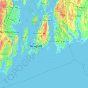
Name: Newport County topographic map, elevation, terrain.
Location: Newport County, Rhode Island, United States (41.30736 -71.50944 41.69050 -71.08857)
Average elevation: 46 ft
Minimum elevation: -23 ft
Maximum elevation: 427 ft
Rhode Island trails, hiking, mountain biking, running and outdoor activities
Make a donation
Gear up for your next adventure:
As an Amazon Associate, this site earns from qualifying purchases at no extra cost to you.
Other topographic maps
Click on a map to view its topography, its elevation and its terrain.
Make a donation
Gear up for your next adventure:
As an Amazon Associate, this site earns from qualifying purchases at no extra cost to you.
Make a donation
Gear up for your next adventure:
As an Amazon Associate, this site earns from qualifying purchases at no extra cost to you.
Touisset Wildlife Refuge
United States > Rhode Island > Bristol County > Warren
Average elevation: 20 ft
Make a donation
Gear up for your next adventure:
As an Amazon Associate, this site earns from qualifying purchases at no extra cost to you.
Diamond Hill Park
United States > Rhode Island > Providence County > Cumberland > Diamond Hill
Average elevation: 272 ft
Make a donation
Gear up for your next adventure:
As an Amazon Associate, this site earns from qualifying purchases at no extra cost to you.
Make a donation
Gear up for your next adventure:
As an Amazon Associate, this site earns from qualifying purchases at no extra cost to you.
Slatersville
United States > Rhode Island > Providence County > North Smithfield
Average elevation: 285 ft
Make a donation
Gear up for your next adventure:
As an Amazon Associate, this site earns from qualifying purchases at no extra cost to you.
Make a donation
Gear up for your next adventure:
As an Amazon Associate, this site earns from qualifying purchases at no extra cost to you.
Wakefield
United States > Rhode Island > South County > South Kingstown > Wakefield
Average elevation: 75 ft
Make a donation
Gear up for your next adventure:
As an Amazon Associate, this site earns from qualifying purchases at no extra cost to you.
Make a donation
Gear up for your next adventure:
As an Amazon Associate, this site earns from qualifying purchases at no extra cost to you.
Jerimoth Hill
United States > Rhode Island > Providence County > Foster
The hill is located on Route 101 in Foster, a half mile from the Connecticut line. To ascend the summit, for which there is a sign, there is a .3-mile (480 m) long trail that has a mere 10-foot (3.0 m) elevation gain. The hill is 812 feet (247 m) high and is located 15 miles (24 km) west of Providence, Rhode…
Average elevation: 709 ft
Make a donation
Gear up for your next adventure:
As an Amazon Associate, this site earns from qualifying purchases at no extra cost to you.
Saunderstown
United States > Rhode Island > South County > North Kingstown > Saunderstown
Average elevation: 46 ft
Olneyville
United States > Rhode Island > Providence County > Providence > Olneyville
Average elevation: 79 ft
Make a donation
Gear up for your next adventure:
As an Amazon Associate, this site earns from qualifying purchases at no extra cost to you.
Conservation Land (Trails)
United States > Rhode Island > Providence County > Cumberland
Average elevation: 240 ft
Make a donation
Gear up for your next adventure:
As an Amazon Associate, this site earns from qualifying purchases at no extra cost to you.