
Olympia topographic map
Interactive map
Click on the map to display elevation.
Olympia
Olympia is characterized by a diverse topography that ranges from coastal lowlands to the gently sloping Cascade foothills to the southeast. The city is perched at an average elevation of about 150 feet above sea level, lying adjacent to Budd Inlet and surrounded by rich, green hills that rise gradually from the shoreline. This terrain is not only scenic but also supports various ecosystems, including wetlands and wooded areas, contributing to the region's biodiversity. The surrounding landscape includes both flat prairie land and forested hills, which provide numerous recreational opportunities and stunning vistas.
About this map
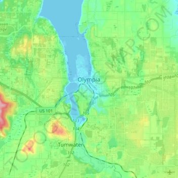
Name: Olympia topographic map, elevation, terrain.
Location: Olympia, Thurston County, Washington, United States (47.00075 -122.97093 47.07823 -122.82315)
Average elevation: 161 ft
Minimum elevation: -3 ft
Maximum elevation: 574 ft
Thurston County trails, hiking, mountain biking, running and outdoor activities
Other topographic maps
Click on a map to view its topography, its elevation and its terrain.