
Celle topographic map
Interactive map
Click on the map to display elevation.
About this map
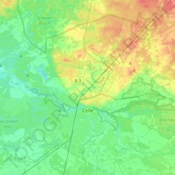
Name: Celle topographic map, elevation, terrain.
Location: Celle, Landkreis Celle, Lower Saxony, Germany (52.56274 9.98289 52.72831 10.21290)
Average elevation: 157 ft
Minimum elevation: 98 ft
Maximum elevation: 272 ft
Other topographic maps
Click on a map to view its topography, its elevation and its terrain.