
Providence topographic map
Interactive map
Click on the map to display elevation.
About this map
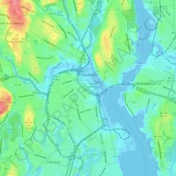
Name: Providence topographic map, elevation, terrain.
Location: Providence, Providence County, Rhode Island, United States (41.77243 -71.47267 41.86180 -71.37361)
Average elevation: 62 ft
Minimum elevation: -26 ft
Maximum elevation: 282 ft
Providence County trails, hiking, mountain biking, running and outdoor activities
Other topographic maps
Click on a map to view its topography, its elevation and its terrain.
Diamond Hill Park
United States > Rhode Island > Providence County > Cumberland > Diamond Hill
Average elevation: 272 ft
Slatersville
United States > Rhode Island > Providence County > North Smithfield
Average elevation: 285 ft
Olneyville
United States > Rhode Island > Providence County > Providence > Olneyville
Average elevation: 79 ft
Conservation Land (Trails)
United States > Rhode Island > Providence County > Cumberland
Average elevation: 240 ft