
Saint Croix District topographic map
Interactive map
Click on the map to display elevation.
About this map
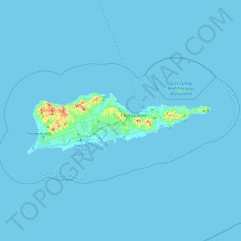
Name: Saint Croix District topographic map, elevation, terrain.
Average elevation: 20 ft
Minimum elevation: 0 ft
Maximum elevation: 1,099 ft
United States Virgin Islands trails, hiking, mountain biking, running and outdoor activities
Other topographic maps
Click on a map to view its topography, its elevation and its terrain.
Little Princess South
United States > United States Virgin Islands > Saint Croix District
Average elevation: 167 ft
Charlotte Amalie West
United States > United States Virgin Islands > Saint Thomas - Saint John District
Average elevation: 171 ft
Contentment
United States > United States Virgin Islands > Saint Croix District
Average elevation: 190 ft
Central
United States > United States Virgin Islands > Saint Thomas - Saint John District
Average elevation: 571 ft
Water Island
United States > United States Virgin Islands > Saint Thomas - Saint John District
Average elevation: 23 ft
Little Saint James Island
United States > United States Virgin Islands > Saint Thomas - Saint John District
Average elevation: 3 ft
Fortuna
United States > United States Virgin Islands > Saint Thomas - Saint John District
Average elevation: 131 ft
Morningstar
United States > United States Virgin Islands > Saint Croix District > Morningstar
Average elevation: 223 ft
Charlotte Amalie
United States > United States Virgin Islands > Saint Thomas - Saint John District > Charlotte Amalie
Average elevation: 203 ft