
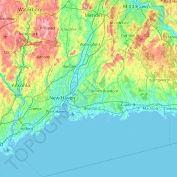
South Central Connecticut Planning Region topographic map
Interactive map
Click on the map to display elevation.
About this map
Name: South Central Connecticut Planning Region topographic map, elevation, terrain.
Average elevation: 197 ft
Minimum elevation: -10 ft
Maximum elevation: 971 ft
Connecticut trails, hiking, mountain biking, running and outdoor activities
Other topographic maps
Click on a map to view its topography, its elevation and its terrain.
Daniels Mill
United States > Connecticut > Western Connecticut Planning Region > New Canaan
Average elevation: 328 ft
Peter's Rock
United States > Connecticut > South Central Connecticut Planning Region > North Haven
Average elevation: 125 ft
Milton Hill
United States > Connecticut > Northwest Hills Planning Region > Goshen
Average elevation: 1,207 ft
Clay Arsenal
United States > Connecticut > Capitol Planning Region > Hartford
Average elevation: 59 ft
Five Points
United States > Connecticut > Western Connecticut Planning Region > Redding Ridge
Average elevation: 607 ft
Drakeville
United States > Connecticut > Northwest Hills Planning Region > Torrington
Average elevation: 1,014 ft
Chimney Point
United States > Connecticut > Western Connecticut Planning Region > New Milford
Average elevation: 466 ft
North End
United States > Connecticut > Capitol Planning Region > Southington
Average elevation: 223 ft
North Mianus
United States > Connecticut > Western Connecticut Planning Region > Greenwich
Average elevation: 105 ft
Indian Cave
United States > Connecticut > South Central Connecticut Planning Region > Guilford
Average elevation: 82 ft
Saugatuck
United States > Connecticut > Western Connecticut Planning Region > Westport
Average elevation: 49 ft
Silver Beach
United States > Connecticut > South Central Connecticut Planning Region > Milford
Average elevation: 16 ft
Hein Trails
United States > Connecticut > South Central Connecticut Planning Region > Bethany > Davidsons Corner
Average elevation: 574 ft
Hanover Reservoir
United States > Connecticut > Southeastern Connecticut Planning Region > Hanover
Average elevation: 299 ft
Grand Staircase
United States > Connecticut > Northwest Hills Planning Region > Kent
Average elevation: 673 ft
Bunker Hill
United States > Connecticut > Naugatuck Valley Planning Region > Waterbury
Average elevation: 459 ft
Northfield
United States > Connecticut > Northwest Hills Planning Region > Litchfield
Average elevation: 850 ft
Giants Neck
United States > Connecticut > Southeastern Connecticut Planning Region > East Lyme
Average elevation: 30 ft
Clark Hill
United States > Connecticut > South Central Connecticut Planning Region > Milford
Average elevation: 36 ft
Sea Bluff
United States > Connecticut > South Central Connecticut Planning Region > West Haven > West Shore
Average elevation: 46 ft
Sunset Hill
United States > Connecticut > South Central Connecticut Planning Region > Branford
Average elevation: 39 ft
Wildmans Landing
United States > Connecticut > Western Connecticut Planning Region > Danbury
Average elevation: 512 ft
Bunker Hill
United States > Connecticut > Naugatuck Valley Planning Region > Waterbury
Average elevation: 459 ft
Brockway
United States > Connecticut > Lower Connecticut River Valley Planning Region > Lyme
Average elevation: 154 ft
Mill River Park
United States > Connecticut > Western Connecticut Planning Region > Stamford
Average elevation: 59 ft
Austrailia Beach
United States > Connecticut > Southeastern Connecticut Planning Region > Mystic
Average elevation: 62 ft
Austrailia Beach
United States > Connecticut > Southeastern Connecticut Planning Region > Mystic
Average elevation: 62 ft
Killingworth Court
United States > Connecticut > South Central Connecticut Planning Region > New Haven
Average elevation: 43 ft
Jordan Village
United States > Connecticut > Southeastern Connecticut Planning Region > Waterford
Average elevation: 89 ft
Bear Mountain
United States > Connecticut > Northwest Hills Planning Region > Salisbury
Bear Mountain is a peak of the southern Taconic Mountains in Salisbury, Connecticut. At 2,316 feet (706 m) (note, per references 1 and 3, there is disagreement about the precise elevation), Bear Mountain is the highest mountain that lies wholly within Connecticut. However, it is not the state highpoint: in the…
Average elevation: 1,785 ft
Bold Rock
United States > Connecticut > Western Connecticut Planning Region > Darien
Average elevation: 190 ft
Godfrey Corner
United States > Connecticut > Western Connecticut Planning Region > Weston
Average elevation: 361 ft
Quiambaug
United States > Connecticut > Southeastern Connecticut Planning Region > Mystic
Average elevation: 26 ft
Sea Bluff
United States > Connecticut > South Central Connecticut Planning Region > West Haven > West Shore
Average elevation: 46 ft
Momauguin
United States > Connecticut > South Central Connecticut Planning Region > East Haven
Average elevation: 10 ft
Blackboys
United States > Connecticut > Southeastern Connecticut Planning Region > East Lyme
Average elevation: 125 ft
Huntley Island
United States > Connecticut > Southeastern Connecticut Planning Region > East Lyme
Average elevation: 23 ft
Clay Arsenal
United States > Connecticut > Capitol Planning Region > Hartford
Average elevation: 59 ft
Blue Lake
United States > Connecticut > Southeastern Connecticut Planning Region > North Stonington
Average elevation: 348 ft
Mystic
United States > Connecticut > Southeastern Connecticut Planning Region
Average elevation: 79 ft
The Matterhorn
United States > Connecticut > Northwest Hills Planning Region > Canaan
Average elevation: 1,516 ft
Millville
United States > Connecticut > Naugatuck Valley Planning Region > Naugatuck
Average elevation: 433 ft
Big Indian
United States > Connecticut > South Central Connecticut Planning Region > Guilford
Average elevation: 135 ft
Washington Depot
United States > Connecticut > Northwest Hills Planning Region > Washington
Average elevation: 758 ft
Oakdale
United States > Connecticut > Southeastern Connecticut Planning Region > Montville
Average elevation: 463 ft
Marble Dale
United States > Connecticut > Northwest Hills Planning Region > Washington
Average elevation: 817 ft
Killingly Center
United States > Connecticut > Northeastern Connecticut Planning Region > Killingly > Dayville
Average elevation: 358 ft
Hurd State Park
United States > Connecticut > Lower Connecticut River Valley Planning Region > East Hampton
Average elevation: 249 ft
Griswoldville
United States > Connecticut > Capitol Planning Region > Wethersfield
Average elevation: 112 ft
Taftville Reservoir #1 Dam
United States > Connecticut > Southeastern Connecticut Planning Region > Norwich
Average elevation: 246 ft
Quiambaug
United States > Connecticut > Southeastern Connecticut Planning Region > Mystic
Average elevation: 26 ft
King Street
United States > Connecticut > Western Connecticut Planning Region > Danbury
Average elevation: 778 ft
South End
United States > Connecticut > Western Connecticut Planning Region > Stamford
Average elevation: 36 ft
Four Corners
United States > Connecticut > Southeastern Connecticut Planning Region > Montville
Average elevation: 354 ft
Bulls Bridge
United States > Connecticut > Northwest Hills Planning Region > Kent
Average elevation: 584 ft
Spoonville
United States > Connecticut > Capitol Planning Region > East Granby
Average elevation: 203 ft
Skinnerville
United States > Connecticut > Lower Connecticut River Valley Planning Region > East Hampton
Average elevation: 430 ft
Mount Higby
United States > Connecticut > Lower Connecticut River Valley Planning Region > Middletown
Average elevation: 440 ft
Town Plot Hill
United States > Connecticut > Naugatuck Valley Planning Region > Waterbury
Average elevation: 417 ft
Hadlyme
United States > Connecticut > Lower Connecticut River Valley Planning Region > Lyme
Average elevation: 148 ft
Warsaw Park
United States > Connecticut > Naugatuck Valley Planning Region > Ansonia
Average elevation: 351 ft
Minortown
United States > Connecticut > Naugatuck Valley Planning Region > Woodbury
Average elevation: 554 ft
Pleasant Valley
United States > Connecticut > Northwest Hills Planning Region > Barkhamsted
Average elevation: 630 ft
Unionville
United States > Connecticut > Capitol Planning Region > Farmington
Average elevation: 315 ft
Cottage Grove
United States > Connecticut > Capitol Planning Region > Bloomfield
Average elevation: 102 ft
Union City
United States > Connecticut > Naugatuck Valley Planning Region > Naugatuck
Average elevation: 407 ft
Essex
United States > Connecticut > Lower Connecticut River Valley Planning Region
Average elevation: 148 ft
East River
United States > Connecticut > South Central Connecticut Planning Region > Madison
Average elevation: 30 ft
Long Ridge
United States > Connecticut > Western Connecticut Planning Region > Stamford
Average elevation: 413 ft
Fenwood
United States > Connecticut > Lower Connecticut River Valley Planning Region > Old Saybrook
Average elevation: 7 ft
Manitock Spring
United States > Connecticut > Southeastern Connecticut Planning Region > Waterford
Average elevation: 85 ft
Knollwood
United States > Connecticut > Lower Connecticut River Valley Planning Region > Old Saybrook
Average elevation: 7 ft
Forest Heights
United States > Connecticut > South Central Connecticut Planning Region > Milford
Average elevation: 62 ft
Wataba Lake
United States > Connecticut > Western Connecticut Planning Region > Ridgefield
Average elevation: 673 ft
Flanders
United States > Connecticut > Southeastern Connecticut Planning Region > East Lyme
Average elevation: 141 ft
Grove Beach
United States > Connecticut > Lower Connecticut River Valley Planning Region > Westbrook
Average elevation: 23 ft
High Rock
United States > Connecticut > Southeastern Connecticut Planning Region > Waterford
Average elevation: 128 ft
Brightview
United States > Connecticut > South Central Connecticut Planning Region > New Haven
Average elevation: 16 ft
Fort Trumbull
United States > Connecticut > South Central Connecticut Planning Region > Milford
Average elevation: 23 ft
Chesterfield
United States > Connecticut > Southeastern Connecticut Planning Region > Montville
Average elevation: 253 ft
Flanders
United States > Connecticut > Southeastern Connecticut Planning Region > East Lyme
Average elevation: 141 ft
Laysville
United States > Connecticut > Lower Connecticut River Valley Planning Region > Old Lyme
Average elevation: 108 ft
Byram
United States > Connecticut > Western Connecticut Planning Region > Greenwich
Average elevation: 62 ft
Four Corners
United States > Connecticut > Capitol Planning Region > Terramuggus
Average elevation: 469 ft
Bakerville
United States > Connecticut > Northwest Hills Planning Region > New Hartford
Average elevation: 801 ft
Haystack Mountain
United States > Connecticut > Northwest Hills Planning Region > Norfolk
Average elevation: 1,263 ft
West Norwalk
United States > Connecticut > Western Connecticut Planning Region > Norwalk
Average elevation: 164 ft
Morningside
United States > Connecticut > South Central Connecticut Planning Region > Milford
Average elevation: 16 ft
Hamburg
United States > Connecticut > Lower Connecticut River Valley Planning Region > Lyme
Average elevation: 161 ft
Deer Hill
United States > Connecticut > Western Connecticut Planning Region > Danbury
Average elevation: 443 ft
Elmville
United States > Connecticut > Northeastern Connecticut Planning Region > Killingly
Average elevation: 348 ft
Torringford
United States > Connecticut > Northwest Hills Planning Region > Torrington
Average elevation: 988 ft
Cedar Land
United States > Connecticut > Naugatuck Valley Planning Region > Southbury
Average elevation: 338 ft
Godfrey Corner
United States > Connecticut > Western Connecticut Planning Region > Weston
Average elevation: 361 ft
Westview Heights
United States > Connecticut > Naugatuck Valley Planning Region > Middlebury
Average elevation: 522 ft
Mount Carmel Center
United States > Connecticut > South Central Connecticut Planning Region > Hamden
Average elevation: 259 ft
Bayview
United States > Connecticut > South Central Connecticut Planning Region > Milford
Average elevation: 16 ft