
Make a donation
Gear up for your next adventure:
As an Amazon Associate, this site earns from qualifying purchases at no extra cost to you.
South County topographic map
Click on the map to display elevation.
Make a donation
Gear up for your next adventure:
As an Amazon Associate, this site earns from qualifying purchases at no extra cost to you.
South County
According to the U.S. Census Bureau, the county has a total area of 563 square miles (1,460 km2), of which 329 square miles (850 km2) is land and 234 square miles (610 km2) (41%) is water. It is the largest county in Rhode Island by total area. The county's topography ranges from flat along the shoreline to gently rolling hills farther inland. The highest point is a large area approximately 560 feet (171 m) above sea level in the Exeter neighborhood of Black Plain; the lowest point is sea level along the coast. The northern boundary west of Davisville is approximately 41.60°N. The western boundary north of Westerly is approximately 71.79°W.
Make a donation
Gear up for your next adventure:
As an Amazon Associate, this site earns from qualifying purchases at no extra cost to you.
About this map
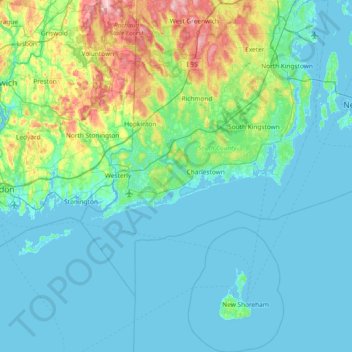
Name: South County topographic map, elevation, terrain.
Location: South County, Rhode Island, United States (41.09583 -71.90743 41.65531 -71.38209)
Average elevation: 98 ft
Minimum elevation: -16 ft
Maximum elevation: 643 ft
Rhode Island trails, hiking, mountain biking, running and outdoor activities
Make a donation
Gear up for your next adventure:
As an Amazon Associate, this site earns from qualifying purchases at no extra cost to you.
Other topographic maps
Click on a map to view its topography, its elevation and its terrain.
Make a donation
Gear up for your next adventure:
As an Amazon Associate, this site earns from qualifying purchases at no extra cost to you.
Make a donation
Gear up for your next adventure:
As an Amazon Associate, this site earns from qualifying purchases at no extra cost to you.
Touisset Wildlife Refuge
United States > Rhode Island > Bristol County > Warren
Average elevation: 20 ft
Diamond Hill Park
United States > Rhode Island > Providence County > Cumberland > Diamond Hill
Average elevation: 272 ft
Make a donation
Gear up for your next adventure:
As an Amazon Associate, this site earns from qualifying purchases at no extra cost to you.
Make a donation
Gear up for your next adventure:
As an Amazon Associate, this site earns from qualifying purchases at no extra cost to you.
Make a donation
Gear up for your next adventure:
As an Amazon Associate, this site earns from qualifying purchases at no extra cost to you.
Slatersville
United States > Rhode Island > Providence County > North Smithfield
Average elevation: 285 ft
Make a donation
Gear up for your next adventure:
As an Amazon Associate, this site earns from qualifying purchases at no extra cost to you.
Make a donation
Gear up for your next adventure:
As an Amazon Associate, this site earns from qualifying purchases at no extra cost to you.
Wakefield
United States > Rhode Island > South County > South Kingstown > Wakefield
Average elevation: 75 ft
Make a donation
Gear up for your next adventure:
As an Amazon Associate, this site earns from qualifying purchases at no extra cost to you.
Olneyville
United States > Rhode Island > Providence County > Providence > Olneyville
Average elevation: 79 ft
Make a donation
Gear up for your next adventure:
As an Amazon Associate, this site earns from qualifying purchases at no extra cost to you.
Jerimoth Hill
United States > Rhode Island > Providence County > Foster
The hill is located on Route 101 in Foster, a half mile from the Connecticut line. To ascend the summit, for which there is a sign, there is a .3-mile (480 m) long trail that has a mere 10-foot (3.0 m) elevation gain. The hill is 812 feet (247 m) high and is located 15 miles (24 km) west of Providence, Rhode…
Average elevation: 709 ft
Make a donation
Gear up for your next adventure:
As an Amazon Associate, this site earns from qualifying purchases at no extra cost to you.
Saunderstown
United States > Rhode Island > South County > North Kingstown > Saunderstown
Average elevation: 46 ft
Conservation Land (Trails)
United States > Rhode Island > Providence County > Cumberland
Average elevation: 240 ft
Make a donation
Gear up for your next adventure:
As an Amazon Associate, this site earns from qualifying purchases at no extra cost to you.
Make a donation
Gear up for your next adventure:
As an Amazon Associate, this site earns from qualifying purchases at no extra cost to you.