
Washington topographic map
Interactive map
Click on the map to display elevation.
Washington
Washington sits along the Potomac River in a region characterized by relatively low and gradual terrain. The city's central area is largely flat, with elevation rising slightly to the north and south. The highest natural point is located at Fort Reno Park in the northwest, reaching 409 feet (125 meters) above sea level, while the lowest point lies at sea level along the Potomac River's banks. Surrounding the city, gentle hills and rolling land define the topography, especially noticeable in areas such as the eastern bank of the Anacostia River. The area also features prominent geologic formations, such as igneous plutons visible in places like Rock Creek Park, adding geological variety to the terrain.
About this map
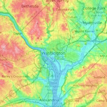
Name: Washington topographic map, elevation, terrain.
Location: Washington, District of Columbia, United States (38.79163 -77.11979 38.99597 -76.90937)
Average elevation: 171 ft
Minimum elevation: -10 ft
Maximum elevation: 453 ft
District of Columbia trails, hiking, mountain biking, running and outdoor activities
Other topographic maps
Click on a map to view its topography, its elevation and its terrain.
United States National Arboretum
United States > District of Columbia > Washington
Average elevation: 69 ft
United States National Arboretum
United States > District of Columbia > Washington
Average elevation: 69 ft
Theodore Roosevelt Island
United States > District of Columbia > McLean
The island's vegetation is quite diverse for a relatively small area, due to its geological and topographic variety, the frequency of floods, its land-use history (including various periods of landscaping), and its location in an urban area in which many non-native species occur. Most of the island is…
Average elevation: 62 ft