Geolocate

Peebles topographic map

Click on the map to display elevation.

About this map

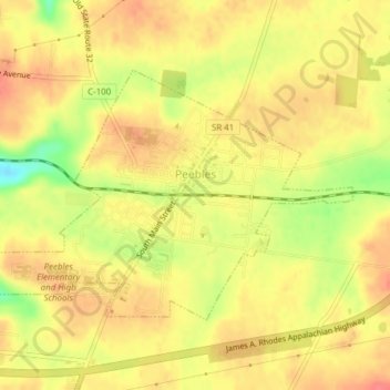
Name: Peebles topographic map, elevation, terrain.

Location: Peebles, Meigs Township, Adams County, Ohio, United States (38.93782 -83.42806 38.95821 -83.39492)

Average elevation: 830 ft

Minimum elevation: 712 ft

Maximum elevation: 879 ft

Adams County trails, hiking, mountain biking, running and outdoor activities

Other topographic maps

Click on a map to view its topography, its elevation and its terrain.

Louden

United States > Ohio > Adams County

Average elevation: 794 ft

Ohio Brush Creek

United States > Ohio > Adams County

Average elevation: 892 ft

Tranquility

United States > Ohio > Adams County

Average elevation: 837 ft

Whippoorwill

United States > Ohio > Adams County > Whippoorwill

Average elevation: 804 ft

Gear up for your next adventure:

🧯Portable Fire Pit - Compact fire pit for camping spots
🏥Hiking First Aid Kits - Comprehensive medical kits for remote trail injuries
⛑️Personal Locator Beacon - Safety beacon for emergencies
🧣Merino Neck Gaiters - Multi-functional headwear for wind and sun protection
🛡️Insect Repellent - Protection against bugs during outdoor activities

As an Amazon Associate, this site earns from qualifying purchases at no extra cost to you.