Geolocate

Dysselsdorp topographic map

Click on the map to display elevation.

About this map

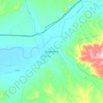
Name: Dysselsdorp topographic map, elevation, terrain.

Location: Dysselsdorp, George, Western Cape, South Africa (-33.61361 22.39333 -33.53361 22.47333)

Average elevation: 1,440 ft

Minimum elevation: 1,112 ft

Maximum elevation: 2,667 ft

Other topographic maps

Click on a map to view its topography, its elevation and its terrain.

Oudtshoorn

South Africa > Western Cape > George

Average elevation: 1,158 ft

Touwsranten

South Africa > Western Cape > George

Average elevation: 663 ft

Danabaai

South Africa > Western Cape > George

Average elevation: 358 ft

Garden Route Dam

South Africa > Western Cape > George

Average elevation: 656 ft

Friemersheim

South Africa > Western Cape > George

Average elevation: 860 ft

Oudtshoorn

South Africa > Western Cape > George

Average elevation: 1,158 ft

Oudtshoorn

South Africa > Western Cape > George

Average elevation: 1,158 ft

Gear up for your next adventure:

💧Water Purification System - Clean water on the trail with reliable purifiers
🎒Hydration Pack - Hands‑free water reservoir for long hikes
🧺Microfiber Travel Towels - Compact and fast-drying towels for trail use
☀️Outdoor Sunscreen - High protection sunscreen for outdoor activities
🧦Merino Wool Socks - Moisture-wicking, blister-preventing socks for long treks

As an Amazon Associate, this site earns from qualifying purchases at no extra cost to you.