Geolocate

Lemon Bay topographic map

Click on the map to display elevation.

About this map

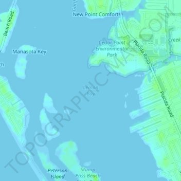
Name: Lemon Bay topographic map, elevation, terrain.

Location: Lemon Bay, Englewood, Charlotte County, Florida, 34224, United States (26.91946 -82.34181 26.91956 -82.34171)

Average elevation: 3 ft

Minimum elevation: -7 ft

Maximum elevation: 26 ft

Charlotte County trails, hiking, mountain biking, running and outdoor activities

Other topographic maps

Click on a map to view its topography, its elevation and its terrain.

Gear up for your next adventure:

🏥Hiking First Aid Kits - Comprehensive medical kits for remote trail injuries
🛌Ultralight Sleeping Bags - Compact down bags for cold nights in the wilderness
📌Outdoor GPS Map App - Apps and devices for digital topographic navigation
📚Navigation Handbooks - Master the art of reading topographic maps and using a compass
🧢Sun Protection Hats - Wide-brimmed and UPF-rated hats for high-altitude sun safety

As an Amazon Associate, this site earns from qualifying purchases at no extra cost to you.