Geolocate

Trowbridge topographic map

Click on the map to display elevation.

About this map

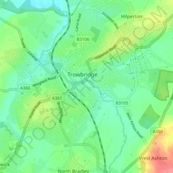
Name: Trowbridge topographic map, elevation, terrain.

Location: Trowbridge, Wiltshire, England, United Kingdom (51.29480 -2.23556 51.33752 -2.17347)

Average elevation: 154 ft

Minimum elevation: 82 ft

Maximum elevation: 315 ft

Gear up for your next adventure:

🗺️Topographic Maps - Detailed topo maps for hiking, exploring and outdoor navigation
🔪Outdoor Multitools - Essential survival tools for gear repair and field use
🎒Gear Packing Cubes - Organize your backpack efficiently
🏕️Tent Footprint - Protect your tent base from wear
🧷Carabiner Set - Durable clips for gear attachment

As an Amazon Associate, this site earns from qualifying purchases at no extra cost to you.