
Make a donation
Gear up for your next adventure:
As an Amazon Associate, this site earns from qualifying purchases at no extra cost to you.
Oos topographic map
Click on the map to display elevation.
Make a donation
Gear up for your next adventure:
As an Amazon Associate, this site earns from qualifying purchases at no extra cost to you.
About this map
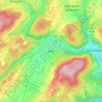
Name: Oos topographic map, elevation, terrain.
Average elevation: 1,545 ft
Minimum elevation: 1,243 ft
Maximum elevation: 1,906 ft
Make a donation
Gear up for your next adventure:
As an Amazon Associate, this site earns from qualifying purchases at no extra cost to you.
Other topographic maps
Click on a map to view its topography, its elevation and its terrain.
Müllenborn
Deutschland > Rheinland-Pfalz > Landkreis Vulkaneifel > Gerolstein
Durch seine Karstquellen ist die Gegend von Müllenborn schon seit jeher sehr wasserreich. Daher wurden bereits im Frühmittelalter fünf Mühlen betrieben, die dem Ort seinem Namen gaben und vor allem bei der Holz- und Eisenverarbeitung eingesetzt wurden. Die Wasserenergie wurde auch zum Betrieb eines…
Average elevation: 1,512 ft
Lissingen
Deutschland > Rheinland-Pfalz > Landkreis Vulkaneifel > Gerolstein
Average elevation: 1,371 ft
Gerolsteiner Dolomiten (Auberg, Munterley, Hustley, Papenkaule und Juddenkirchhof)
Deutschland > Rheinland-Pfalz > Landkreis Vulkaneifel > Gerolstein
Average elevation: 1,424 ft
Make a donation
Gear up for your next adventure:
As an Amazon Associate, this site earns from qualifying purchases at no extra cost to you.
Michelbach
Deutschland > Rheinland-Pfalz > Landkreis Vulkaneifel > Gerolstein > Büscheich
Average elevation: 1,647 ft