
San Angelo topographic map
Click on the map to display elevation.
About this map
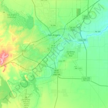
Name: San Angelo topographic map, elevation, terrain.
Location: San Angelo, Tom Green County, Texas, United States (31.33550 -100.52929 31.52649 -100.35993)
Average elevation: 1,890 ft
Minimum elevation: 1,759 ft
Maximum elevation: 2,205 ft
Tom Green County trails, hiking, mountain biking, running and outdoor activities
Other topographic maps
Click on a map to view its topography, its elevation and its terrain.