
Thank you for supporting this site ❤️
Make a donation
Make a donation
Gear up for your next adventure:
As an Amazon Associate, this site earns from qualifying purchases at no extra cost to you.
Pardollán topographic map
Click on the map to display elevation.
Thank you for supporting this site ❤️
Make a donation
Make a donation
Gear up for your next adventure:
As an Amazon Associate, this site earns from qualifying purchases at no extra cost to you.
About this map
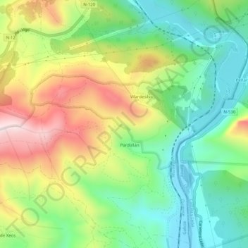
Name: Pardollán topographic map, elevation, terrain.
Location: Pardollán, Rubiá, Valdeorras, Orense, Galicia, 32329, España (42.43893 -6.85026 42.47587 -6.81088)
Average elevation: 1,923 ft
Minimum elevation: 1,211 ft
Maximum elevation: 3,028 ft
Thank you for supporting this site ❤️
Make a donation
Make a donation
Gear up for your next adventure:
As an Amazon Associate, this site earns from qualifying purchases at no extra cost to you.