
Thank you for supporting this site ❤️
Make a donation
Make a donation
Gear up for your next adventure:
As an Amazon Associate, this site earns from qualifying purchases at no extra cost to you.
Lampang topographic map
Click on the map to display elevation.
Thank you for supporting this site ❤️
Make a donation
Make a donation
Gear up for your next adventure:
As an Amazon Associate, this site earns from qualifying purchases at no extra cost to you.
About this map
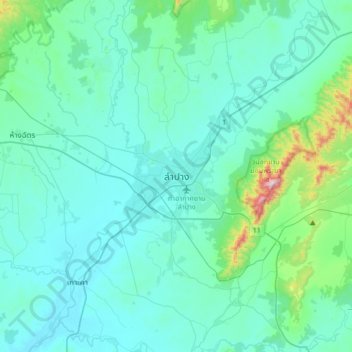
Name: Lampang topographic map, elevation, terrain.
Location: Lampang, Ton Thong Chai, Lampang Province, 14001, Thailand (18.12995 99.33585 18.44995 99.65585)
Average elevation: 961 ft
Minimum elevation: 702 ft
Maximum elevation: 2,927 ft
Thank you for supporting this site ❤️
Make a donation
Make a donation
Gear up for your next adventure:
As an Amazon Associate, this site earns from qualifying purchases at no extra cost to you.