Geolocate

Port Huron topographic map

Click on the map to display elevation.

About this map

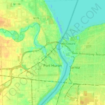
Name: Port Huron topographic map, elevation, terrain.

Location: Port Huron, Saint Clair County, Michigan, United States (42.93685 -82.46653 43.04125 -82.39903)

Average elevation: 607 ft

Minimum elevation: 568 ft

Maximum elevation: 653 ft

Saint Clair County trails, hiking, mountain biking, running and outdoor activities

Other topographic maps

Click on a map to view its topography, its elevation and its terrain.

Starville

United States > Michigan > Saint Clair County

Average elevation: 594 ft

Berville

United States > Michigan > Saint Clair County

Average elevation: 797 ft

Goodells

United States > Michigan > Saint Clair County

Average elevation: 709 ft

Jeddo

United States > Michigan > Saint Clair County

Average elevation: 728 ft

Gear up for your next adventure:

🌲Outdoor Survival Books - Best books on survival skills
🦺Reflective Outdoor Gear - Safety gear for low‑light conditions
🔋Solar Power Banks - Keep your GPS and phone charged in remote wilderness areas
🪶Survival Guide Book - Expert advice for emergency preparedness
🔭Compact Binoculars - HD vision for scouting terrain and identifying distant landmarks

As an Amazon Associate, this site earns from qualifying purchases at no extra cost to you.