
Santa Giustina in Colle topographic map
Interactive map
Click on the map to display elevation.
About this map
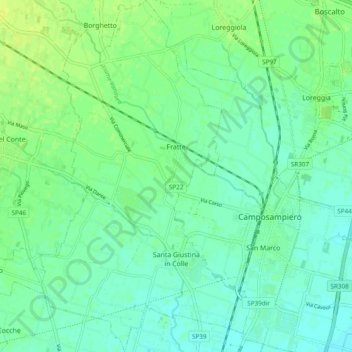
Name: Santa Giustina in Colle topographic map, elevation, terrain.
Location: Santa Giustina in Colle, Padova, Venetien, Italien (45.54600 11.86923 45.61306 11.92667)
Average elevation: 85 ft
Minimum elevation: 62 ft
Maximum elevation: 115 ft
Other topographic maps
Click on a map to view its topography, its elevation and its terrain.
Due Carrare
Due Carrare, Padova, Venetien, Italien
Average elevation: 30 ft