
Calder River topographic map
Interactive map
Click on the map to display elevation.
About this map
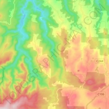
Name: Calder River topographic map, elevation, terrain.
Location: Calder River, Burnie, Tasmania, 7320, Australia (-41.16626 145.61050 -41.06889 145.68539)
Average elevation: 886 ft
Minimum elevation: 230 ft
Maximum elevation: 1,713 ft
Other topographic maps
Click on a map to view its topography, its elevation and its terrain.
Shorewell Park
Shorewell Park, Burnie, City of Burnie, Tasmania, Australia
Average elevation: 443 ft
Emu Heights
Emu Heights, Burnie, City of Burnie, Tasmania, 7320, Australia
Average elevation: 230 ft
Upper Burnie
Upper Burnie, Burnie, City of Burnie, Tasmania, 7320, Australia
Average elevation: 364 ft