Geolocate

Pali topographic map

Click on the map to display elevation.

About this map

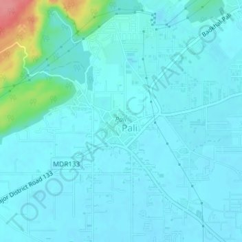
Name: Pali topographic map, elevation, terrain.

Location: Pali, Faridabad, Haryana, India (28.37667 77.23731 28.38367 77.24745)

Average elevation: 692 ft

Minimum elevation: 653 ft

Maximum elevation: 938 ft

Other topographic maps

Click on a map to view its topography, its elevation and its terrain.

Faridabad

India > Haryana > Faridabad

Average elevation: 712 ft

Manger

India > Haryana > Faridabad

Average elevation: 879 ft

Libiza town

India > Haryana > Faridabad

Average elevation: 725 ft

Tigaon

India > Haryana > Faridabad

Average elevation: 663 ft

Faridabad

India > Haryana > Faridabad

Average elevation: 712 ft

Kant Enclave

India > Haryana > Faridabad > Faridabad

Average elevation: 817 ft

Gear up for your next adventure:

🌡️Handheld Weather Meters - Measure wind, temp, and pressure for safe mountain travel
📌Outdoor GPS Map App - Apps and devices for digital topographic navigation
😴Insulated Sleeping Pads - Compact and warm pads for high-elevation camping
🔥Fast-Boil Camping Stoves - Efficient cooking systems for quick trail meals
🛠️Backpacking Tool Kit - Essential toolkit for outdoor repairs

As an Amazon Associate, this site earns from qualifying purchases at no extra cost to you.