
Thank you for supporting this site ❤️
Make a donation
Make a donation
Gear up for your next adventure:
As an Amazon Associate, this site earns from qualifying purchases at no extra cost to you.
Massenberg topographic map
Click on the map to display elevation.
Thank you for supporting this site ❤️
Make a donation
Make a donation
Gear up for your next adventure:
As an Amazon Associate, this site earns from qualifying purchases at no extra cost to you.
About this map
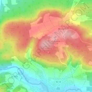
Name: Massenberg topographic map, elevation, terrain.
Location: Massenberg, Spalt, Landkreis Roth, Bayern, 91174, Deutschland (49.19140 10.92055 49.19150 10.92065)
Average elevation: 1,427 ft
Minimum elevation: 1,181 ft
Maximum elevation: 1,670 ft
Thank you for supporting this site ❤️
Make a donation
Make a donation
Gear up for your next adventure:
As an Amazon Associate, this site earns from qualifying purchases at no extra cost to you.