
Make a donation
Gear up for your next adventure:
As an Amazon Associate, this site earns from qualifying purchases at no extra cost to you.
Dschang topographic map
Click on the map to display elevation.
Make a donation
Gear up for your next adventure:
As an Amazon Associate, this site earns from qualifying purchases at no extra cost to you.
Dschang
Due to its high elevation of over 1400 m, Dschang is favoured by relatively cool temperatures and attractive scenery. It is therefore regarded as a mountain tourist resort. Since colonial times, Dschang has been an important agricultural center. Pig production plays a major role.
Make a donation
Gear up for your next adventure:
As an Amazon Associate, this site earns from qualifying purchases at no extra cost to you.
About this map
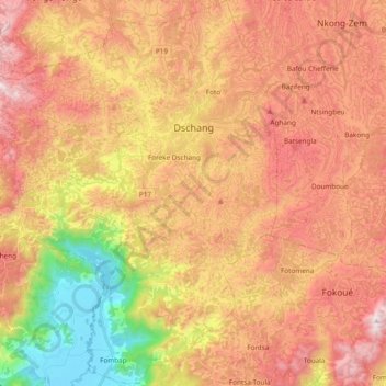
Name: Dschang topographic map, elevation, terrain.
Location: Dschang, Menoua, West, Cameroon (5.32022 9.93577 5.50921 10.09429)
Average elevation: 4,462 ft
Minimum elevation: 2,343 ft
Maximum elevation: 6,148 ft
Make a donation
Gear up for your next adventure:
As an Amazon Associate, this site earns from qualifying purchases at no extra cost to you.