Geolocate

The Island topographic map

Click on the map to display elevation.

About this map

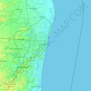
Name: The Island topographic map, elevation, terrain.

Location: The Island, Chennai, Tamil Nadu, 600001, India (12.75529 79.95901 13.39529 80.59901)

Average elevation: 36 ft

Minimum elevation: -7 ft

Maximum elevation: 522 ft

Other topographic maps

Click on a map to view its topography, its elevation and its terrain.

Pallikaranai Marsh

India > Tamil Nadu > Chennai

Average elevation: 7 ft

Sholinganallur lake

India > Tamil Nadu > Chennai

Average elevation: 10 ft

Zone 8 Anna Nagar

India > Tamil Nadu > Chennai

Average elevation: 43 ft

Retteri Lake

India > Tamil Nadu > Chennai

Average elevation: 33 ft

Ward 43

India > Tamil Nadu > Chennai

Average elevation: 16 ft

Zone 10 Kodambakkam

India > Tamil Nadu > Chennai

Average elevation: 43 ft

okkiyam maduvu

India > Tamil Nadu > Chennai

Average elevation: 7 ft

Guindy National Park

India > Tamil Nadu > Chennai

Average elevation: 43 ft

Zone 13 Adyar

India > Tamil Nadu > Chennai

Average elevation: 20 ft

Marina Beach

India > Tamil Nadu > Chennai

Average elevation: 13 ft

Anna Nagar Tower Park

India > Tamil Nadu > Chennai

Average elevation: 46 ft

Eco Park

India > Tamil Nadu > Chennai

Average elevation: 39 ft

Ward 121

India > Tamil Nadu > Chennai

Average elevation: 26 ft

North River

India > Tamil Nadu > Chennai

Average elevation: 26 ft

Gear up for your next adventure:

🗻Climbing Gear Basics - Essential gear for beginner climbers
🦟Ultrasonic Repellers - Create a bug-free zone at your camp or rest stop
📚USA Hiking Guide Books - Top trail guides and map books
Camping Coffee Makers - Enjoy premium coffee at the summit or campsite
🌡️Portable Weather Meter - Track weather conditions on the trail

As an Amazon Associate, this site earns from qualifying purchases at no extra cost to you.