
Make a donation
Gear up for your next adventure:
As an Amazon Associate, this site earns from qualifying purchases at no extra cost to you.
Effringen topographic map
Click on the map to display elevation.
Make a donation
Gear up for your next adventure:
As an Amazon Associate, this site earns from qualifying purchases at no extra cost to you.
About this map
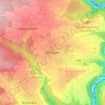
Name: Effringen topographic map, elevation, terrain.
Average elevation: 1,683 ft
Minimum elevation: 1,191 ft
Maximum elevation: 1,985 ft
Make a donation
Gear up for your next adventure:
As an Amazon Associate, this site earns from qualifying purchases at no extra cost to you.
Other topographic maps
Click on a map to view its topography, its elevation and its terrain.
Gültlingen
Deutschland > Baden-Württemberg > Landkreis Calw > Wildberg
Zur Stadt Wildberg gehören die fünf Stadtteile Wildberg, Effringen, Gültlingen, Schönbronn und Sulz am Eck. Im heutigen Umfang entstand die Stadt im Zuge der Gemeindereform der siebziger Jahre. Zunächst wurde am 1. April 1971 Schönbronn nach Wildberg eingemeindet. Am 1. Januar 1975 schlossen sich dann…
Average elevation: 1,722 ft
Make a donation
Gear up for your next adventure:
As an Amazon Associate, this site earns from qualifying purchases at no extra cost to you.