Geolocate

Lanzhou topographic map

Click on the map to display elevation.

About this map

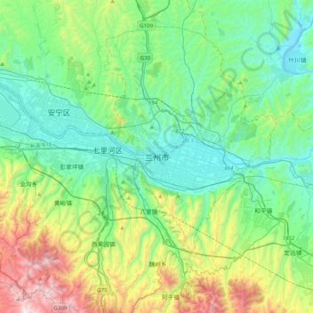
Name: Lanzhou topographic map, elevation, terrain.

Location: Lanzhou, Chengguan District, Lanzhou, Gansu, 730030, China (35.90208 103.67186 36.22208 103.99186)

Average elevation: 6,014 ft

Minimum elevation: 4,846 ft

Maximum elevation: 9,501 ft

Other topographic maps

Click on a map to view its topography, its elevation and its terrain.

Xincheng

China > Gansu > Jiayuguan

Average elevation: 4,859 ft

Baiyin City

China > Gansu

Average elevation: 6,142 ft

Yellow River

China > Gansu > Maqu County > Gaoyuan Institute of Biology

Average elevation: 11,588 ft

Gear up for your next adventure:

🧯Emergency Survival Kit - All‑in‑one survival essentials for the backcountry
🏥Hiking First Aid Kits - Comprehensive medical kits for remote trail injuries
🦶Hiking Gaiters - Keep debris and water out of your boots
🌎3D Topographic Globes - Raised relief globes for a tactile understanding of geography
🧣Merino Neck Gaiters - Multi-functional headwear for wind and sun protection

As an Amazon Associate, this site earns from qualifying purchases at no extra cost to you.