Geolocate

Xincheng topographic map

Click on the map to display elevation.

About this map

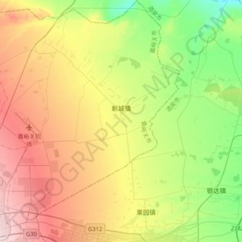
Name: Xincheng topographic map, elevation, terrain.

Location: Xincheng, 郊区, Jiayuguan, Gansu, China (39.75240 98.26910 39.97103 98.52008)

Average elevation: 4,859 ft

Minimum elevation: 4,455 ft

Maximum elevation: 5,404 ft

Gear up for your next adventure:

🔌Solar Panel Charger - Charge gear sustainably outdoors
🦶Hiking Gaiters - Keep debris and water out of your boots
🪄Magnetic Compass - Accurate compass for navigation
📻Weather Alert Radios - Stay informed of storm risks while off-the-grid
🧯Portable Fire Pit - Compact fire pit for camping spots

As an Amazon Associate, this site earns from qualifying purchases at no extra cost to you.