Geolocate

Filiel topographic map

Click on the map to display elevation.

About this map

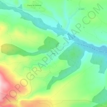
Name: Filiel topographic map, elevation, terrain.

Location: Filiel, Lucillo, León, Castile and León, 24723, Spain (42.35819 -6.35338 42.39819 -6.31338)

Average elevation: 3,845 ft

Minimum elevation: 3,455 ft

Maximum elevation: 4,596 ft

Gear up for your next adventure:

🪶Compact Camp Shovel - Folding shovel for campsite tasks
🧭Compass with Lanyard - Easy‑carry compass for navigation
🔦Powerful Headlamps - Ultra-bright hands-free lighting for night navigation
🧥Waterproof Jacket for Hiking - Breathable and rugged rain jacket for outdoor excursions
💧Water Purification System - Clean water on the trail with reliable purifiers

As an Amazon Associate, this site earns from qualifying purchases at no extra cost to you.