Geolocate

Tichborne topographic map

Click on the map to display elevation.

About this map

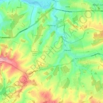
Name: Tichborne topographic map, elevation, terrain.

Location: Tichborne, Winchester, Hampshire, England, United Kingdom (51.01654 -1.24155 51.08715 -1.15588)

Average elevation: 335 ft

Minimum elevation: 161 ft

Maximum elevation: 591 ft

Other topographic maps

Click on a map to view its topography, its elevation and its terrain.

Flagpond Copse

United Kingdom > England > Hampshire > Winchester

Average elevation: 85 ft

Pitt

United Kingdom > England > Hampshire > Winchester > Pitt

Average elevation: 335 ft

Gear up for your next adventure:

🎒Outdoor Daypacks - Lightweight backpacks designed for carrying maps and essential gear
🪶Compact Camp Shovel - Folding shovel for campsite tasks
📻Weather Alert Radios - Stay informed of storm risks while off-the-grid
🧭Orienteering Set - Complete compass and map reading kit
🧦Merino Wool Socks - Moisture-wicking, blister-preventing socks for long treks

As an Amazon Associate, this site earns from qualifying purchases at no extra cost to you.