
Make a donation
Gear up for your next adventure:
As an Amazon Associate, this site earns from qualifying purchases at no extra cost to you.
Jostedalsbreen nasjonalpark topographic map
Click on the map to display elevation.
Make a donation
Gear up for your next adventure:
As an Amazon Associate, this site earns from qualifying purchases at no extra cost to you.
About this map
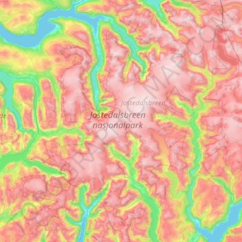
Name: Jostedalsbreen nasjonalpark topographic map, elevation, terrain.
Location: Jostedalsbreen nasjonalpark, Norway (61.36102 6.44750 61.91084 7.43488)
Average elevation: 3,202 ft
Minimum elevation: 0 ft
Maximum elevation: 6,667 ft
Make a donation
Gear up for your next adventure:
As an Amazon Associate, this site earns from qualifying purchases at no extra cost to you.
Other topographic maps
Click on a map to view its topography, its elevation and its terrain.
Make a donation
Gear up for your next adventure:
As an Amazon Associate, this site earns from qualifying purchases at no extra cost to you.
Snøhetta
Snøhetta is the highest mountain in the Dovrefjell mountain range in Norway. At 2,286 metres (7,500 ft), it is the highest mountain in Norway outside the Jotunheimen range, making it the 24th highest peak in Norway, based on a 30-metre (98 ft) topographic prominence cutoff. At 1,675 metres (5,495 ft), its…
Average elevation: 6,276 ft
Make a donation
Gear up for your next adventure:
As an Amazon Associate, this site earns from qualifying purchases at no extra cost to you.
Make a donation
Gear up for your next adventure:
As an Amazon Associate, this site earns from qualifying purchases at no extra cost to you.
Make a donation
Gear up for your next adventure:
As an Amazon Associate, this site earns from qualifying purchases at no extra cost to you.
Make a donation
Gear up for your next adventure:
As an Amazon Associate, this site earns from qualifying purchases at no extra cost to you.
Make a donation
Gear up for your next adventure:
As an Amazon Associate, this site earns from qualifying purchases at no extra cost to you.