
Thank you for supporting this site ❤️
Make a donation
Make a donation
Gear up for your next adventure:
As an Amazon Associate, this site earns from qualifying purchases at no extra cost to you.
Lehn topographic map
Click on the map to display elevation.
Thank you for supporting this site ❤️
Make a donation
Make a donation
Gear up for your next adventure:
As an Amazon Associate, this site earns from qualifying purchases at no extra cost to you.
About this map
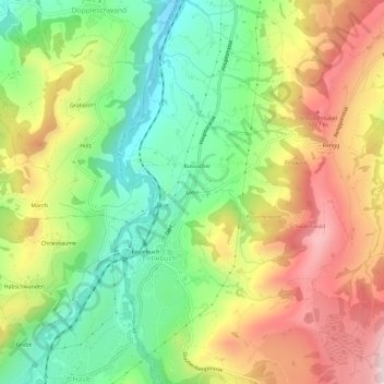
Name: Lehn topographic map, elevation, terrain.
Location: Lehn, Entlebuch, Luzern, 6162, Schweiz (46.97907 8.04959 47.01907 8.08959)
Average elevation: 2,717 ft
Minimum elevation: 2,024 ft
Maximum elevation: 3,573 ft
Thank you for supporting this site ❤️
Make a donation
Make a donation
Gear up for your next adventure:
As an Amazon Associate, this site earns from qualifying purchases at no extra cost to you.