
Make a donation
Gear up for your next adventure:
As an Amazon Associate, this site earns from qualifying purchases at no extra cost to you.
58513 topographic map
Click on the map to display elevation.
Make a donation
Gear up for your next adventure:
As an Amazon Associate, this site earns from qualifying purchases at no extra cost to you.
About this map
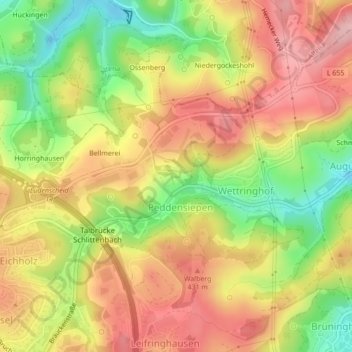
Name: 58513 topographic map, elevation, terrain.
Average elevation: 1,260 ft
Minimum elevation: 965 ft
Maximum elevation: 1,496 ft
Make a donation
Gear up for your next adventure:
As an Amazon Associate, this site earns from qualifying purchases at no extra cost to you.
Other topographic maps
Click on a map to view its topography, its elevation and its terrain.
Ossenberg
Deutschland > Nordrhein-Westfalen > Märkischer Kreis > Lüdenscheid
Average elevation: 1,217 ft
Rahmede
Deutschland > Nordrhein-Westfalen > Märkischer Kreis > Lüdenscheid > Gevelndorf
Average elevation: 1,230 ft
Oedenthal
Deutschland > Nordrhein-Westfalen > Märkischer Kreis > Lüdenscheid
Average elevation: 1,198 ft
Winkhausen
Deutschland > Nordrhein-Westfalen > Märkischer Kreis > Lüdenscheid
Average elevation: 1,112 ft
Make a donation
Gear up for your next adventure:
As an Amazon Associate, this site earns from qualifying purchases at no extra cost to you.
Schwiendahl
Deutschland > Nordrhein-Westfalen > Märkischer Kreis > Lüdenscheid
Average elevation: 1,391 ft
Homert
Deutschland > Nordrhein-Westfalen > Märkischer Kreis > Lüdenscheid
Auf Wanderwegen finden sich Möglichkeiten für Spaziergänge und Wanderungen, zum Beispiel zu den zuvor genannten Stauseen. Die wenige Meter nördlich der Homert gelegene Wanderwegskreuzung liegt auf 530,1 m Höhe.
Average elevation: 1,493 ft
Hulsberg
Deutschland > Nordrhein-Westfalen > Märkischer Kreis > Lüdenscheid
Average elevation: 1,250 ft
Make a donation
Gear up for your next adventure:
As an Amazon Associate, this site earns from qualifying purchases at no extra cost to you.
Neuenhof
Deutschland > Nordrhein-Westfalen > Märkischer Kreis > Lüdenscheid
Average elevation: 1,309 ft
Bellmerei
Deutschland > Nordrhein-Westfalen > Märkischer Kreis > Lüdenscheid > Bellmerei
Average elevation: 1,257 ft
Neuenhof
Deutschland > Nordrhein-Westfalen > Märkischer Kreis > Lüdenscheid
Average elevation: 1,309 ft