
City of Plattsburgh topographic map
Interactive map
Click on the map to display elevation.
About this map
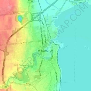
Name: City of Plattsburgh topographic map, elevation, terrain.
Location: City of Plattsburgh, Clinton County, New York, United States (44.66715 -73.48399 44.72467 -73.42916)
Average elevation: 164 ft
Minimum elevation: 75 ft
Maximum elevation: 358 ft
Clinton County trails, hiking, mountain biking, running and outdoor activities
Other topographic maps
Click on a map to view its topography, its elevation and its terrain.
Ellenburg Mountain
United States > New York > Clinton County > Town of Ellenburg
Average elevation: 2,238 ft