Geolocate

Serang topographic map

Click on the map to display elevation.

About this map

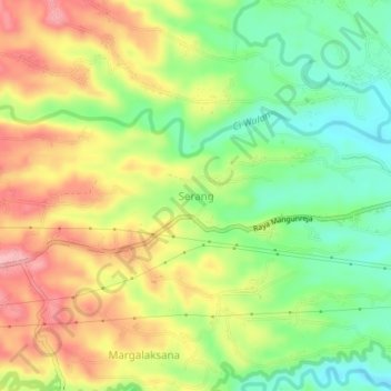
Name: Serang topographic map, elevation, terrain.

Location: Serang, Tasikmalaya, West Java, Java, 46462, Indonesia (-7.39016 108.04837 -7.35016 108.08837)

Average elevation: 1,542 ft

Minimum elevation: 1,325 ft

Maximum elevation: 1,788 ft

Other topographic maps

Click on a map to view its topography, its elevation and its terrain.

Desa Cimanuk

Indonesia > West Java > Tasikmalaya

Average elevation: 105 ft

Cipanas

Indonesia > West Java > Tasikmalaya

Average elevation: 384 ft

Desa Arjasari

Indonesia > West Java > Tasikmalaya

Average elevation: 1,490 ft

Gear up for your next adventure:

🪶Survival Guide Book - Expert advice for emergency preparedness
Backpacking Tents - Weight-optimized shelters for multi-day topographic surveys
📱Solar Portable Charger - Solar power bank for charging devices off‑grid
🛌Ultralight Sleeping Bags - Compact down bags for cold nights in the wilderness
🚪Portable Camp Chair - Foldable chair for comfort at camp

As an Amazon Associate, this site earns from qualifying purchases at no extra cost to you.